Wednesday, March 31, 2021

Re-discovering America, the Park-to-Park Highway Series – Part 4 of 4


After visiting Yosemite, General Grant and Sequoia National Parks, the Park-To-Park Highway group left the mountain climate behind them and headed into warmer weather. They continued on to Bakersfield on October 19th, where they were met by the automobile Club of California, and one other surprise visitor, who had emerged from his hospital bed.


The great pathfinder, Anton Westgard.


His desire to see through the tour temporarily outweighed his illness, but unfortunately, he could only rejoin the tour as far as Los Angeles. As the group moved west, Westgard traveled south to San Diego, where his health continued to decline. He would not rejoin the tour.


Park to Park Highway, Part 4


The Auto Club of Southern California had hosted them during their stay in Los Angeles, and when the group left, they traveled on what today is the famous Route 66. Traveling now in desert conditions dotted with Joshua trees, they journeyed to the next park on the list.


Zion National Park


With the intensely dry heat of the Mohave Desert being a constant companion, the Park-to-Park tour group's resolve was beginning to wane. Dust was an ever-present fixture on the road and it permeated everything, from their clothes to the engines of their automobiles. Their journey continued north, and after 4,000 miles of travel, a 500-mile trip to Zion National Park seemed not only impossible, but unbearable.


What's more, they simply had no time to spare.


But what they did not realize was the beautiful other-worldly sights they would miss at Zion. With its sheer sandstone cliffs and green oasis in the desert, they could not fathom the scenery unless they saw it with their own eyes. Located on the edge of the Colorado Plateau, the rock that was pushed up over millions of years started to erode away, leaving a unique landscape with colorful rock formations and a desert river at the bottom, forming a ribbon of green in the middle of an arid land.


Oblivious to Zion's wonders, the party soldiered on.


Grand Canyon National Park


Even though Zion was bypassed, the group could not have anticipated the spectacular vistas they were about to experience. On October 26th, the caravan crossed the border into Arizona, arriving at El Tovar Hotel at the south rim of the Grand Canyon.


They were not prepared for the truly awe-inspiring sight of endless miles of steep cliffs and colorful strada, made possible by the eroding force of the Colorado River. At some points, the Canyon is a mile deep; the result of millions of years of erosion and a perfect recording of the Earth's history.


The unbelievable spectacle of seeing the Grand Canyon for their first time has been known to leave some visitors so overcome that they simply faint, or sink down to their knees, crying with joy and wonder.


Varying from 4 to 8 miles wide, the Grand Canyon stretches for 277 miles. Previously set aside by past presidents as first a forest, and then a game reserve, it wasn't until 1919 that Congress made it a national park. In 1902, the first automobile came to the Grand Canyon from Flagstaff along a stagecoach route. Back then, that journey took 4 days. Construction of Rim Road began in 1908.


The tour group spent 3 days at the Canyon. On October 30th, they traveled on to Flagstaff. They continued east, stopping by Petrified Forest National Monument.


By now it was November and winter was catching up. With the weather becoming a deterrent, they had to shift their itinerary and ship the cars up to Pueblo, Colorado. The trip had become too cumbersome for some and a few of the members left the tour to catch a train back home.


The remainder of the group took a train to Durango. 


Mesa Verde National Park


Despite the inclement weather, Steven Mathers joined the rest of the group for the final push to Mesa Verde. It was the only park on their journey to feature man-made structures, where the Pueblo people built their homes and sacred spaces 900 years ago. In a mysterious move, these ancient citizens abandoned their home and when the Europeans discovered it several centuries later, it became jeopardized when early tourists took delicate artifacts; some even vandalizing the area.


It was then a group of ladies who realized they had to do something about it. Around the 1890's they began advocating for Mesa Verde to become a protected national park, and in 1906, their efforts paid off. Not only did they protect the cliff dwellings, but they commissioned the building of wells, trails, and eventually roads.


When Steven Mather and company arrived at the park on November 6th, 1920, only one major road had been built so far, the Knife Edge Trail. Back in 1917, Horace Albright described this road as “one of the most disreputable, dangerous, fearsome bits of slippery rotted misery I ever had the misfortune to travel.”


This, of course, gave the Park-to-Park tour a renewed sense of their mission to preach the gospel of good roads.


Home Again, Home Again


After touring the last park on their grand circle tour, they headed back to Denver to attend a convention to further discuss the creation of good roads. But before that, they held their last meeting in Pueblo at the Congress Hotel. Then, on November 9th, the tour drove up South Broadway into Denver after 76 days of almost constant travel which saw them being escorted by 60 automobiles and a welcome banquet.


The group was able to show the world that visiting these national parks could be possible on passable roads going from park to park. Seven of the original 12 members completed the entire tour.


Anton Westgard was one of the more notable figures not in attendance that day. Alas, he had to remain in San Diego, as late-stage syphilis ravaged his body. He succumbed to the disease on April 3, 1921. He was 66 years old.


Later that year, Congress began the process of getting good paved roads to link the parks together, eventually creating the Park to Park Highway. It was a direct result of the enthusiasm that this tour created. These roads provided a whole new scale of American tourism. It opened the door to the concept that the almighty road trip is part of the American dream of adventure, freedom, and exploration.


Mathers, Westgard, and the entire Park-to-Park team literally paved the way for the Great American Road Trip, and of re-discovering the amazing beauty of the American West.


Click here to read Part 1 of the Park-to-Park Highway series...


or


Click here to read Part 3 of the Park-to-Park Highway series...


Meet Rob Decker, Creator of National Park Posters


Photographer and graphic artist Rob Decker studied photography with Ansel Adams in Yosemite National Park during the summer of 1979 when he was just 19. It was an experience solidified his love of photography and our National Parks. Now he is on a journey to photograph and create iconic WPA-style posters of all our major national parks as we celebrate the next 100 years of the National Park Service.


"I feel it's important to protect America's special places, and to connect people with nature. And it's up to all of us to pitch in. Perhaps more importantly, we need to inspire the next generation of park stewards. I'm trying to make a difference by giving back to the amazing organizations that support our National Parks. I donate 10% of annual profits, so when you buy one of these original works, you're helping these trusts, conservancies and associations, too."


Click here to meet the artist, Rob Decker.


Join the growing community of 75k+ National Park enthusiasts to receive insider deals and updates.


See why 75k+ National Park fans have already joined...


Source: https://national-park-posters.com/blogs/national-park-posters/park-to-park-highway-series-part-4
attachement

Tuesday, March 30, 2021

Re-discovering America, the Park-to-Park Highway Series – Part 3 of 4


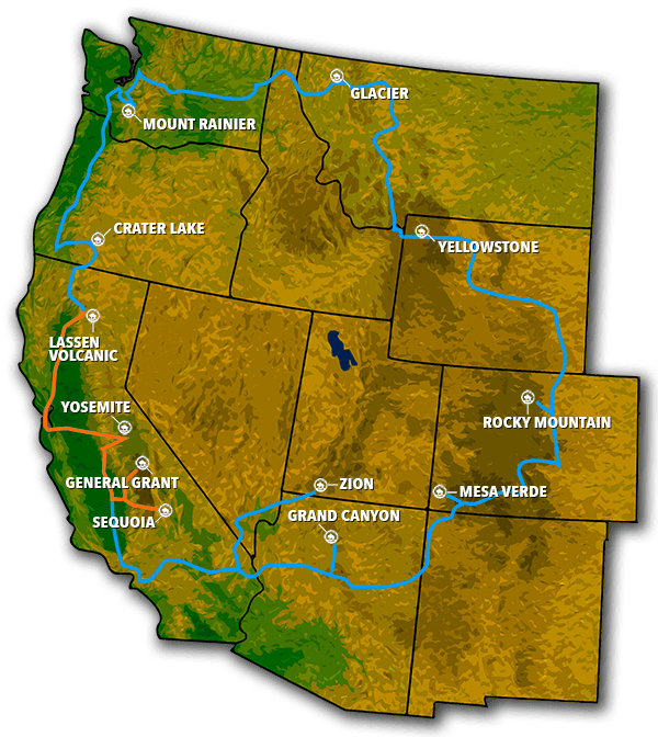
We rejoin the Park-to-Park tour group at their halfway point. After driving long hours to get to Lassen National Park and discovering they could not tour the park due to lack of roads, the group pressed on, through snowy conditions to Yosemite.


Park-To-Park Highway, Part 3


Yosemite National Park


Carl Sharsmith was a ranger who worked in the park nearly every summer from his late 20's all the way until his death at age 91. He is said to have explored every nook and cranny of Yosemite's High Sierra. There is a story that park rangers at Yosemite always love to tell. One day in his later years, a woman visitor to the park approached Sharsmith and asked, “I have one hour to tour Yosemite. What shall I see?”


Sharsmith stroked his beard, and after some careful thought, pointed down to a rock. “See that rock down there by the river? Well, if I were you and only had one hour to tour Yosemite, I would just walk down to that rock, have a seat, and I'd just cry.”


Home to cliffs of sheer white granite, cascading waterfalls, and massive trees as far as the eye can see, Yosemite holds so many majestic vistas. It was drastically different from anything the tour had yet witnessed. It was the famous naturalist John Muir was in many ways responsible for Yosemite's existence.


Likewise, Steven Mather dedicated much of his personal resources for the betterment of the park. It was, after all, his favorite. It was his passion for the area that allowed him to acquire Tioga Road and complete it so that visitors to the park could easily access it.


The Park-to-Park tour group spent their first night in Yosemite at the Sentinel Hotel, and had a spectacular viewing of the famous Firefall. A campfire was built using the wood from Red Fir. The campfire would burn all day, then in the evening around 9pm there was a ritual in Curry Village where locals would gather round to sing an Indian love song, then proclaim, “Let the fire fall!” then shovel the embers from the fire over the cliff, creating a dramatic spectacle of a waterfall of fire.


The tour continued through the park on Glacier Road, ascending to 3,200 feet to Glacier Point Hotel. This brought them to the best views of Yosemite. During the development of the park, workers used the principles of landscape architecture in order for the park to be accessible to visitors, and yet still look natural and rustic. Using timber and stone, they created facilities that perfectly blended into the landscape.


After a 3rd night in the park, the group said ‘goodbye' to Yosemite and continued on to the next National Park. 


Driving through the San Joaquin Valley through Madera and Fresno, the group arrived at the gateway to Sequoia and General Grant national park. 


General Grant National Park


Created in 1890, the park was established to protect the General Grant grove of giant sequoia trees and an amazing section of what is now Kings Canyon National Park. The shining star is the General Grant Tree, which towers 267 feet tall, is 1,500 years old, and is the 3rd largest tree in the world. At 154 acres, this section of the park is geographically isolated from the rest of Kings Canyon National Park.


The park is composed of two distinct areas – Grant Grove and Cedar Grove. Kings Canyon is also home to Redwood Canyon, the largest remaining grove of sequoia trees in the world.


In 1873, the renowned naturalist John Muir hiked from Yosemite to the giant forest of sequoias. Afterwards, Muir became a staunch advocate for federal protection of the region. The dramatic landscape of this region is testimony to nature's size, beauty, and diversity – with towering mountains, rugged foothills, deep canyons, vast caverns, and the some of the world's largest trees. In fact, Muir called this area “a rival to Yosemite.”


Sequoia National Park


When the tour arrived at Sequoia National Park on October 17th, Superintendent John R. White led group through the 2nd oldest national park in the U.S. (next to Yellowstone), where the group found themselves in a wilderness of giants.


With some trees towering up to 300 feet tall, this was quite a sight and like nothing they had seen before. Each of the monolithic trees were hundreds of years old and captured the imagination of everyone. The mere fact that these trees were huge, old, and rare, provided the perfect trifecta of fascination.


Before the park came to be, loggers naturally gravitated to these gentle giants as a great source of wood. Indeed, it was one example of the threats our national parks face with respect to logging, mining, ranching, etc. and another reason why all of the parks gained protection under the federal level in order to preserve the natural beauty of our nation.


The tour group reveled in the sight of these trees, taking numerous pictures of themselves being dwarfed by the giant Sequoia.


The next day, a snow storm drove them out of the park; the first severe winter weather the group had encountered on the Park-to-Park tour.


Their next stops: Zion, Grand Canyon and Mesa Verde, which we'll take up in Part 4 of our Park-to-Park series!


Click here to read Part 2 of the Park-to-Park Highway series...


Meet Rob Decker, Creator of National Park Posters


Photographer and graphic artist Rob Decker studied photography with Ansel Adams in Yosemite National Park during the summer of 1979 when he was just 19. It was an experience solidified his love of photography and our National Parks. Now he is on a journey to photograph and create iconic WPA-style posters of all our major national parks as we celebrate the next 100 years of the National Park Service.


"I feel it's important to protect America's special places, and to connect people with nature. And it's up to all of us to pitch in. Perhaps more importantly, we need to inspire the next generation of park stewards. I'm trying to make a difference by giving back to the amazing organizations that support our National Parks. I donate 10% of annual profits, so when you buy one of these original works, you're helping these trusts, conservancies and associations, too."


Click here to meet the artist, Rob Decker.


Join the growing community of 75k+ National Park enthusiasts to receive insider deals and updates.


See why 75k+ National Park fans have already joined...


Source: https://national-park-posters.com/blogs/national-park-posters/park-to-park-highway-series-part-3

attachement

Thursday, March 25, 2021

RE-DISCOVERING AMERICA, THE PARK-TO-PARK HIGHWAY SERIES – PART 2 OF 4


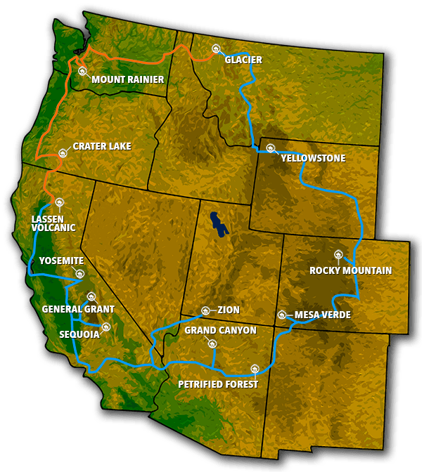
We continue our journey with the idealistic members of the Park-to-Park tour as they leave the west side of Glacier National Park. After taking the train through the remainder of Glacier's tour, they picked up their automobiles on September 14, 1920 to continue on to the next park, crossing into Idaho.


Click here if you haven't already read Part 1


Even though the members of the tour were wined and dined by officials at most every stop they made, it was still a necessity to bring adequate supplies, including food, with them during the long treks in between. Items such as canned meat, beans, crackers, canned fruit, and milk chocolate provided sustenance on the road, and would help ensure their survival should the caravan break down.


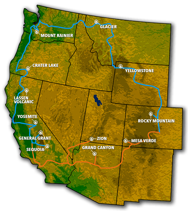
Park-to-Park Map, Part 2 | National Park Posters


But things were about to get tough.


It was about this time that their fearless leader, Anton Westgard, developed complications from late-stage syphilis. As they crossed into Washington State and arrived in Spokane, at the insistence of his doctor, he left the party on a train bound for San Francisco for immediate treatment. The hard knocks of constant auto travel over the last 18 years took its toll on him, and every jolt of his automobile racked his weakening body. He had to leave the tour.


With the tour not even halfway completed, the group were on their own. Now they had a tough decision to make. Should they go back the way they came and risk the approaching winter weather over the Rocky Mountains? Or abandon the marked route altogether and make a beeline back to Denver? The other option, of course, was to finish the work Westgard had begun, and soldier on for the remaining 3,000 miles to complete the tour, thus completing the adventure of their lives.


Without the immeasurable expertise of Westgard (who had already staked out and driven the entire loop) the party had a rough idea of which roads to take, but they were unsure of what they would encounter on those roads.


Given the odds, the decision was clear – they would continue on, using Westgard's instructions and his detailed notes on the road conditions that lie ahead of them. On to Mount Rainier they went!


Gus Holmes, Chairman of the National Park-to-Park Association, was their new leader.


Mount Rainier


As the tour soldiered west through the towns of Cle Elum, Seattle and Tacoma, the weather turned gloomy – it was classic Pacific Northwest weather, but everyone along the way gave them a hearty welcome. On September 25, Rainier loomed large before them – a gigantic solitary mountain with glaciers flanking the sides.


The first successful climb of Mount Rainier happened in 1870, and became a national park in 1899. By 1920, nearly 30 miles of road were constructed in and around Mountain Rainier National Park. President Taft toured the park in 1911 and was in one of the first cars to drive the switchback roads up the mountain and make it all the way to Paradise Valley.


Click here to see the Mount Rainier National Park Poster.


When the Park-to-Park group arrived, they drove the same roads, and spent two days in Paradise Valley, soaking up the grandeur of the park.


Continuing on, the traveled west, stopping at Camp Lewis, a military outpost. Following the Pacific highway south, they were forced to stop near the Oregon border. Up until now the tour had kept to its rigorous schedule. But because one of the cars became stuck on a muddy detour near the town of Kelso, the tour ground to a halt on September 29.


It was to be the only delay on their entire journey. Eventually, a big white truck came to pull the car out of the muck, and the tour carried on. All along the way, the group continued to be greeted with great fanfare in every town they stopped at, including Portland, Oregon.


Crater Lake National Park


Being wined and dined all along the way, fried chicken seemed to be the standard main course of every meal. But when they arrived at Crater Lake Lodge in Crater Lake National Park, they got a special treat; a meal with duck and venison – and not a chicken in sight. Located at the summit of Mount Mazama, they were given exclusive access to the lodge and the surrounding Rim Road, which circumvents the stunning caldera volcano which created America's deepest lake.


At 33 miles long, Rim Road hugs the edge of Crater Lake, which dips down steeply, giving the road a unique role in one's experience with the surrounding landscape. Solely because of this, the engineers who built Rim Road had to get things right. The idea was to enable visitors to enjoy the scenery of the lake, and not worry about muddy conditions, potholes, and the like.


Click here to see the Crater Lake National Park Poster


In fact, this was largely true for most all roads that traversed the national parks up until the 1920's. Landscape engineers were tasked with building roads that allowed the utmost opportunity to the glorious views of the parks, and many winding roads were built. As a result, the vast majority of park visitors never strayed far from their cars when touring the parks, which also aided in the conservation of the surrounding interior and wilderness.


Lassen Volcanic National Park


Established in 1914, Lassen includes hot springs, pristine lakes, and cinder cones. Truly spectacular scenery. Lassen Peak's last eruption was May 30, 1914, and was the first ever modern recording of an eruption. A particularly large blast happened the following year, and continued to spew steam and explosions for the next two years.


At only 106,000 acres, Lassen is one of the smallest national parks, and yet holds examples of each of the four types of volcanoes found throughout the world. Its biodiversity is stunning. To get there safely, the tour hurried on through Medford, Ashland and the Siskiyou Mountain to avoid bad weather.


Click here to see the Lassen Volcanic National Park Poster


On October 7, they approached Lassen, but found they could not enter the park. The culprit was something the group had been dealing with all throughout the tour to some degree.


No roads had yet been set up in the park. They just simply weren't there. Because of this, they were forced to skip Lassen and move on, passing through Red Bluff, Chico, and Marysville. They took the ferry toward Oakland to San Francisco, and stopped in Stockton over snowy roads.


Their next stop: Steven Mather's favorite park, which we'll take up in Part 3 of our Park-to-Park series!


Click here to read Part 1 of the Park-to-Park Highway series...


Meet Rob Decker, Creator of National Park Posters


Photographer and graphic artist Rob Decker studied photography with Ansel Adams in Yosemite National Park during the summer of 1979 when he was just 19. It was an experience solidified his love of photography and our National Parks. Now he is on a journey to photograph and create iconic WPA-style posters of all our major national parks as we celebrate the next 100 years of the National Park Service.


"I feel it's important to protect America's special places, and to connect people with nature. And it's up to all of us to pitch in. Perhaps more importantly, we need to inspire the next generation of park stewards. I'm trying to make a difference by giving back to the amazing organizations that support our National Parks. I donate 10% of annual profits, so when you buy one of these original works, you're helping these trusts, conservancies and associations, too."


Click here to meet the artist, Rob Decker.


Join the growing community of 75k+ National Park enthusiasts to receive insider deals and updates.


See why 75k+ National Park fans have already joined...


Source: https://national-park-posters.com/blogs/national-park-posters/park-to-park-highway-series-part-2

attachement

Tuesday, March 23, 2021

Re-discovering America, the Park-to-Park Highway Series – Part 1 of 4


For National Park enthusiasts and adventurers who have a penchant for history, this is an especially gripping tale.


During the time of WWI, when most of America's roads and highways were still unpaved, a group of 12 people undertook the journey of a lifetime. A 5,000 mile, 76-day loop which can aptly be described as “a lariat lassoing the scenic wonders of the west”. These scenic wonders were the 13 national parks that were currently in existence at that time.


National park officials and automobile enthusiasts were invited to participate in this epic journey. In August of 1920, a group of 12 men and their companions set out to help promote these parks by participating in the “Park to Park” journey.


It was the brainchild of Steven Mathers, the first director of the National Park Service in 1916. He visited these parks and realized that in order for folks to come out and enjoy the parks, a road infrastructure needed to be put in place – something that had not yet come to fruition at that time. It was an ambitious undertaking with the overarching goal for people to be encouraged to experience the beauty, wonder and grandeur of the national parks. The theme was “See America First.”


Park to Park Highway - Part 1


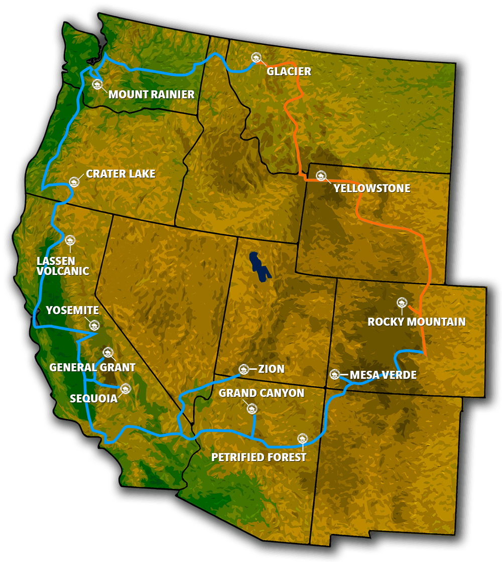
Beginning in Denver on August 26th, the trip would take the group through Rocky Mountain, Yellowstone, Glacier, Mount Rainier, Crater Lake, Lassen Volcanic, Yosemite, General Grant, Sequoia, Zion, Grand Canyon, Mesa Verde, Petrified Forest and back to Denver.


Anton Westgard was the group's field guide. He also happened to be AAA's Field Representative. Quite the character, he was known as “the pathfinder” of the trip. He had formidable navigational skills and took over the daunting task of deciding which roads to take throughout the trip.


Said Stephen T. Mathers, “The main objective is to present to the people of the country a panorama of our principal national parks. Set side by side, for their study and comparison. Each park will be highly individual. The whole will be a revelation.”


Rocky Mountain National Park


The first stop on their journey was Estes Park, Colorado, the gateway to Rocky Mountain National Park. The road from Estes Park up the mountain was scenic but treacherous, with many switchbacks, and many cars of the day could not handle the conditions. Despite this, due to the easy proximity of the park to Denver, this national park saw many more visitors than the other parks of its time. Rocky Mountain National Park quickly became the poster child of the sole purpose of the Park-to-Park tour: where good roads and accessibility were available, the tourists would come.


 After a night at Estes Park, the caravan set out again, bound for Yellowstone. Keeping to a rigorous schedule, the members of the tour were already given a complete itinerary and knew exactly where they would be staying. Their message was clear: with good roads come good tourism, and a shining beacon to exploring all America's nature had to offer.

The members of the tour group sang this message loud and proud all along the way to local officials throughout their journey.


Some of the roads were treacherous, some were good. Thankfully, the next leg of the tour was relatively painless, as Yellowstone Highway was finished just three months earlier, complete with road signs.


Click here to see the Rocky Mountain National Park Poster.


With the Good Roads Movement, and Mathers' campaign to get decent roads to the national parks, the idea of a national roads system began in the 1920s and the national government did indeed improve roads to the park. Up until now, most roads were dirt. And when it rained, those roads turned into absolute mud baths; often impassable. Something had to change.


Yellowstone National Park


On the 3rd of September, the caravan took Yellowstone Road to Yellowstone National Park (Wyoming), where the group stayed at the Lake Hotel. Here their schedule allowed them to spend 4 days exploring the park's natural wonders.


Back in 1920, when a car approached the park entrance, an inspection took place that was more about how well the car was equipped than about what you were going to see in Yellowstone. If you didn't have the correct gear and know-how about how to repair your car in case of a breakdown, you were simply not allowed inside the park.


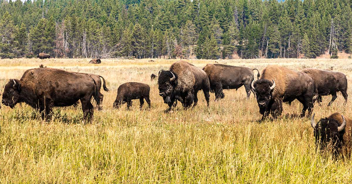
Established in 1872, the park was one of the first created at the federal level as a National Park. The group experienced the geothermal oddities of Old Faithful, Grand Prismatic Spring, the Grand Canyon of Yellowstone, and many other features of the park's caldera. Great American bison roamed free throughout, as well as mule deer, elk, pronghorn sheep, bears, and wolves. But the main reason the park was created was due to the amazing geysers, which was an oddity of these lands.


Click here to see the Yellowstone National Park Poster.


On Sept. 7th, they left Mammoth Springs Hotel and crossed into Montana. Glacier National Park awaited them 400 miles and 4.5 days later. They traveled the Yellowstone-Glacier Beeline Highway.


Glacier National Park


Founded in 1910, Glacier National Park came into being as the 10th national park. Because the Great Northern Railroad still had the upper hand on transportation inside the park, there were not yet any real roads to speak of, so the group's vehicles had to be sent on to Belton while they visited the park in white tour buses.


Mountains, lakes, and 60 glaciers were their scenery – glaciers that cut into mountains and created the lakes we see today. Because the roads were still being worked on, they hoped that their message of good road building would eventually come to fruition here so that more people could have access to this park.


Click here to see the Glacier National Park Poster.


Reaching the west side of Glacier NP and the town of Belton on Sept. 14th, the caravan moved on further west to rough roads ahead. That begins the tale in the next part in this series.


Stay tuned for: Re-discovering America, the Park-to-Park Highway Series – Part 2


MEET ROB DECKER, CREATOR OF NATIONAL PARK POSTERS


Photographer and graphic artist Rob Decker studied photography with Ansel Adams in Yosemite National Park during the summer of 1979 when he was just 19. It was an experience solidified his love of photography and our National Parks. Now he is on a journey to photograph and create iconic WPA-style posters of all our major national parks as we celebrate the next 100 years of the National Park Service.


"I feel it's important to protect America's special places, and to connect people with nature. And it's up to all of us to pitch in. Perhaps more importantly, we need to inspire the next generation of park stewards. I'm trying to make a difference by giving back to the amazing organizations that support our National Parks. I donate 10% of annual profits, so when you buy one of these original works, you're helping these trusts, conservancies and associations, too."


Click here tot meet the artist, Rob Decker.


Source: https://national-park-posters.com/blogs/national-park-posters/park-to-park-highway-series-part-1

attachement

Saturday, March 20, 2021

Spring is a great time to explore Utah's National Parks


The five national parks in Utah draw several million visitors from around the world each year to marvel at surreal scenery and create their own unforgettable experiences. A trip to these parks includes watching the sunrise over the towering depths of Canyonlands National Park, then watching the sunset through Delicate Arch in Arches National Park. You can see ancient petroglyphs in Capitol Reef National Park, then watch a beautiful meteor shower streaks across the Milky Way. Gaze down at coral-hued rock hoodoos in Bryce Canyon National Park or gaze upward at the steep walls of slot canyon trails in Zion National Park. You can hike, river raft, bike, picnic, 4-wheel drive, walk, and even ride a mule to experience these amazing landscapes, their vibrant culture and rich history.


Thursday, March 4, 2021

Hot Springs National Park


Hot Springs National Park was first called Hot Springs Reservation -- and was initially created by an act of Congress on April 20, 1832 — even before the concept of a national park existed. It was the first time that a piece of land had been set aside by the federal government for the people as an area for recreation.


For centuries, the hot spring water was believed to possess medicinal properties — and the subject of legend among several Native American tribes. Following federal protection, the city developed into a successful spa town and has been home to Major League Baseball spring training, illegal gambling, speakeasies and gangsters such as Al Capone, horse racing at Oaklawn Park, the Army and Navy Hospital, and 42nd President Bill Clinton.


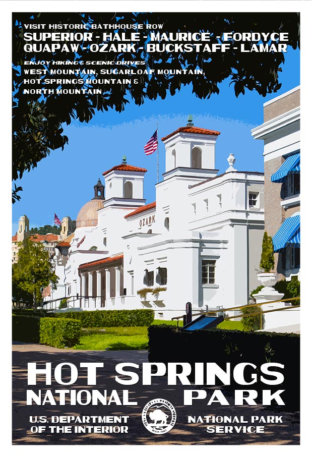
The park includes portions of downtown Hot Springs, making it one of the most accessible national parks. Bathing in spring water is available in approved facilities and the entire Bathhouse Row area is designated as a National Historic Landmark District. It contains the grandest collection of bathhouses of its kind in North America, including many outstanding examples of Gilded Age architecture. The row's Fordyce Bathhouse serves as the park's visitor center and Buckstaff and Quapaw still operate as bathhouses.


Click here to see the Hot Springs National Park poster.


Rob Decker is a photographer and graphic artist with a single passion for our National Parks! Rob is on a journey to explore and photograph each of our national parks and to create WPA-style posters to celebrate the amazing landscapes, vibrant culture and rich history that embody America's Best Idea!


Source: https://national-park-posters.com/blogs/national-park-posters/hot-springs-national-park

attachement

Channel Islands National Park – the Galapagos of North America


Comprising five gorgeous islands along California's Santa Barbara Channel, Channel Islands National Park enjoys a unique ocean environment. The islands of San Miguel, Santa Rosa, Santa Cruz, Anacapa, and Santa Barbara are shrouded in mist and close to the mainland but seem worlds away from the hustle and bustle of nearby Los Angeles.


Yellow Coreopsis & the Anacapa Lighthouse


Yellow Coreopsis & the Anacapa Lighthouse


Perhaps it is the more than 2,000 plant and animal species, of which 145 are found nowhere else on the planet, that makes these islands so special. The waters off-shore hold untold numbers of whales, dolphins, elephant seals, and some 30 other species of marine life. This abundance of wildlife and incredible scenery has given the national park the unofficial title of “The Galapagos of North America.”


Sea Lion Rookery | Channel Islands National Park


Sea Lion Rookery, Santa Barbara Island


Channel Islands Fox | Channel Islands National Park


The Island Fox - It's found nowhere else on earth!


Each season at this island park brings something special to visitors as California's mild weather allows the park to be open all year round. For spectacular views, Inspiration Point on Anacapa Island offers just that, while lounging sea lions can often be spotted on the rock formations of Cathedral Point. During the busy summer season, the blue whale (the largest animal on Earth) and humpback whales can regularly be spotted as they make their migration up north.


Due to its location, it is one of the least visited national parks in America. Access is only possible via a short ocean voyage or a small-plane commercial flight, and this light visitation has contributed to its remote feeling and the continued protection of fragile natural resources.


Protected by wind and waves, this is a place of solitude and adventure. Anacapa Island juts out of the sea with its craggy volcanic rock, holds an iconic lighthouse, and wildflowers that bring the rocky soil to life. Santa Cruz Island is the largest and most diverse of the islands and is home to 60 plants and animals found nowhere else. Santa Rosa island shelters rare Torrey pine trees, sandstone canyons, and contain vestiges of a ranching past.


Water Canyon Beach and Torrey Pines | Channel Islands National Park


Water Canyon Beach and Torrey Pines, Santa Rosa Island


San Miguel is an island of extremes. Its isolated beaches contain the largest rookeries of seals and sea lions on the planet. Fossilized trees from long ago dot the windy sand dunes. Lastly, the tiny island of Santa Barbara is a mesa framed by twin peaks and steep rock faces, where wildflowers and nesting birds remain untouched. All are surrounded by an underwater national park, one of the world's great marine ecosystems.


A Bit of Channel Islands History


Much like the Galapagos chain of islands in South America, isolation of these islands has given evolution carte blanche to proceed independently, which accounts for the unique species that thrive here.


Dwarf Wooly Mammoth | Channel Islands National Park


Dwarf Wooly Mammoth


Archeologists have discovered some of the oldest known human remains in North America here. They have also discovered the bones of dwarf wooly mammoths, which thrived on the island until the last Ice Age about 11,000 years ago – an incredible insight into coastal southern California as it once was. This area, in addition to about 148 historic village sites spread among the islands, is a true peek into the ancient past.


The native Chumash were one of the most advanced people of their time, flourishing for thousands of years. They developed a complex society where they traded with the mainland in plank canoes, using shell beads for currency. Then the Spaniards arrived in 1542, leading to a tragic end of their society as they were exposed to measles and smallpox, devastating their population. During the 1800s, the descendants of these proud people were moved to the mainland, where they still celebrate their ties to the islands today.


The protection of the Channel Islands was ensured when Congress made this a national park, an international biosphere reserve, and national marine sanctuary in 1980. It established long-term monitoring of ecological information gathering so that scientists could predict future conditions in order to continue its protection, including conservation and restoration programs.


Click here to see the Channel Islands National Park poster.


Rob Decker is a photographer and graphic artist with a single passion for our National Parks! Rob is on a journey to explore and photograph each of our national parks and to create WPA-style posters to celebrate the amazing landscapes, vibrant culture and rich history that embody America's Best Idea!


Source: https://national-park-posters.com/blogs/national-park-posters/channel-islands-national-park-the-galapagos-of-north-america

attachement

Kings Canyon National Park


Kings Canyon National Park and this dramatic landscape, testifies to nature's size, beauty, and diversity--huge mountains, rugged foothills, deep canyons, vast caverns, and the world's largest trees. Kings Canyon was established in 1940 and incorporated General Grant National Park, which was established in 1890 to protect the General Grant Grove of giant sequoias. The park is north of and contiguous with Sequoia National Park; the two are administered by the National Park Service jointly as the Sequoia and Kings Canyon National Parks. They were designated the UNESCO Sequoia-Kings Canyon Biosphere Reserve in 1976.


White Tail Deer, Kings River | Robert B. Decker


Humans have inhabited the area for thousands of years. The first Native Americans in the area were Paiute peoples, who moved into the region from their ancestral home east of Mono Lake. The Paiute Nation people used deer and other small animals for food, as well as acorns. They created trade routes that extended down the eastern slope of the Sierra into the Owens Valley.


Kings Canyon had been known to white settlers since the mid-19th century, but it was not until John Muir first visited in 1873 that the canyon began receiving attention. Muir was delighted at the canyon's similarity to Yosemite Valley, as it reinforced his theory regarding the origin of both valleys, which, though competing with Josiah Whitney's then-accepted theory that the spectacular mountain valleys were formed by earthquake action, Muir's theory later proved correct: that both valleys were carved by massive glaciers during the last Ice Age.


Waterfall, Kings Canyon | Robert B. Decler


Then United States Secretary of the Interior Harold Ickes fought to create the Kings Canyon National Park. He hired Ansel Adams to photograph and document this among other parks, in great part leading to the passage of the bill in March 1940. The bill combined the General Grant Grove with the backcountry beyond Zumwalt Meadow.


Kings Canyon's future was in doubt for nearly fifty years. Some wanted to build a dam at the western end of the valley, while others wanted to preserve it as a park. The debate was settled in 1965, when the valley, along with Tehipite Valley, was added to the park.


Tuesday, March 2, 2021

Mount Rainier – A Young Giant


As the highest peak in Washington State, Mount Rainier is a slumbering behemoth that last erupted in the 1890s. It is a large stratovolcano in the Cascade Range of the Pacific Northwest that has actually erupted thousands of times in its relatively young life.


Mount Rainier from Longmire | National Park PostersIt has three major peaks: Liberty Cap, Point Success, and the summit of Columbia Credit. Noted for its dense expanse of coniferous trees on the lower slopes and scenic alpine meadows, during the warmer months of July and August, wildflowers abound, give the area new life with a kaleidoscope of colors.


Fall Colors, Mount Rainier National Park | National Park PostersDespite its mountainous topography, the national park has several points of entry from the surrounding lowlands, allowing easy access for visitors. Sunrise Visitor Center is a good starting point, as it has much information on the park and is stocked well with maps and books, as well as panoramic views of the mountain and Emmons Glacier. It is also a jumping-off point for numerous trails around the perimeter of Mount Rainier.


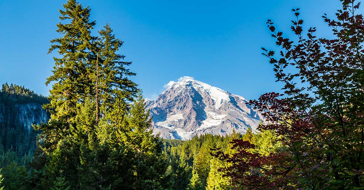
Mount Rainier from Paradise | National Park Posters


Alternatively, Paradise Jackson Visitor Center offers exhibits, ranger programs, and films. Indeed, the little town of Paradise itself is a wonderful home base with which to explore the entire area. In the southeast corner of the park is the Ohanapecosh Visitor Center, nestled among thick old-growth forest and offering a stark contrast to the park's higher altitudes. Here the trees can be up to 300 feet tall and 1,000 years old.


Mowich Lake, Mount Rainier National Park | National Park Posters


Mowich Lake, the park's largest body of water, is the best place for kayaking, canoeing, camping, and many other outdoor activities.


A Bit of Mountain and Park History


Geologically, Mount Rainier is young; formed by a series of lava flows from eruptions starting about one million years ago. It is surrounded by the largest single-mountain glacial system in the U.S. outside of Alaska.


For millennia, the ancestors of modern indigenous people came to the mountain to hunt and gather resources. Today, those tribes strive to continue their deep connection to Mount Rainier. Then, in 1792, early European visitors were captivated by the mountain during their surveying of the Pacific coast. Captain George Vancouver of the British Royal Navy decided to name the mountain after his friend, Rear Admiral Peter Rainier.


It is also one of the nation's oldest parks, which became part of the federal system in 1899, shortly after the last eruption. Its park status was the result of a long campaign by John Muir and his fellow conservationists to preserve this unique forest, field, and glacial landscape under threat from timber and mining extraction that had already adversely affected a good portion of the American West.


Development of the park grew at a torrid and chaotic pace, with the largest balloon in visitation from 1906-1915. During this time, the advent of automobiles made the park more accessible, but this brought its own set of challenges. In fact, it was the first national park to allow cars, and park staff struggled with traffic control. Despite this, all roads that exist today in the park were built by 1930, as well as the majority of the park's infrastructure.


In 1988, the Washington Wilderness Act designated 98% of the park as wilderness, giving the lands greater protection from development.


Click here to see the Mount Rainier National Park poster.


Rob Decker is a photographer and graphic artist with a single passion for our National Parks! Rob is on a journey to explore and photograph each of our national parks and to create WPA-style posters to celebrate the amazing landscapes, vibrant culture and rich history that embody America's Best Idea!


Click here to learn about the Best Things To Do at Mount Rainier National Park.


Source: https://national-park-posters.com/blogs/national-park-posters/mount-rainier-a-young-giant

attachement

World Wildlife Day


On March 3 2021, World Wildlife Day will be celebrated under the theme "Forests and Livelihoods: Sustaining People and Planet", as a way to highlight the central role of forests, forest species and ecosystems services in sustaining the livelihoods of hundreds of millions of people globally, and particularly of Indigenous and local communities with historic ties to forested and forest-adjacent areas. 


World Wildlife Day


On 20 December 2013, at its 68th session, the United Nations General Assembly proclaimed 3 March as UN World Wildlife Day to celebrate and raise awareness of the world's wild animals and plants. World Wildlife Day has now become the most important global annual event dedicated to wildlife.


Between 200 and 350 million people live within or adjacent to forested areas around the world, relying on the various ecosystem services provided by forest and forest species for their livelihoods and to cover their most basic needs, including food, shelter, energy and medicines.


Indigenous peoples and local communities are at the forefront of the symbiotic relationship between humans and forest, forest-dwelling wildlife species and the ecosystem services the provide. Roughly 28% of the world's land surface is currently managed by indigenous peoples, including some of the most ecologically intact forests on the planet. These spaces are not only central to their economic and personal well-being, but also to their cultural identities.


Source: https://national-park-posters.com/blogs/national-park-posters/world-wildlife-day

attachement

Monday, March 1, 2021

Best Things to do in Yellowstone National Park (Part 2)


With a history spanning millions of years and geology that will awe and inspire even the most unimpressionable visitor, the areas of Yellowstone's Grand Canyon and Lower Yellowstone River will leave you breathless – both literally and figuratively!


My name is Rob Decker and I'm a photographer and graphic artist with a single great passion for America's National Parks! There is so much to see and do throughout Yellowstone, it's easy to get overwhelmed – best to take it in stages. This Part 2 article in our 3-part Yellowstone National Park series focuses on the Grand Canyon and lower parts of the park.


Yellowstone's Grand Canyon


This area should be top-of-the-list for any visitor to Yellowstone for one simple reason: The Grand Canyon of the Yellowstone.


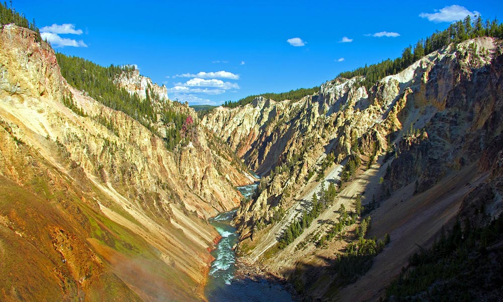
Grand Canyon of the Yellowstone | National Park Posters


If one were to fly high above, what may seem like a loose seam in the fabric of the Earth is actually a 20-mile-long split – a gorge that plummets from a sheer-sided fissure more than 1,000 feet down to the Yellowstone River. In certain places, it widens up to 4,000 feet. Two thundering waterfalls punctuate the river's flow in a palette of bright yellows, oranges, reds, whites, and browns swirling across the rocky depths. A whopping 63,500 gallons of water per second runs through these falls at its peak, then gradually drops to as low as 5,000 gallons per second come late fall.


It's no wonder this area has been the muse of countless artists over the decades. And while this canyon is not nearly as big as the one in Arizona, it is just as impressive. Several miles of hiking trails connect 10 major overlooks, affording dramatic views from both sides of the canyon.


Lower Falls of the Yellowstone River


The lower falls owe their existence to bands of hard volcanic rock. These bands did not erode as quickly as the surrounding softer stuff; consequently, the more resistant spots formed dramatic drops over which the raging river plummets, with dramatic effect. The colors continue throughout, made possible by the minerals taking up residence in the rock, such as iron in the rhyolite. Different layers of rock are exposed, and varying stages of oxidation transform the surrounding cliffs into wonderful hues.


Lower Falls, Yellowstone River | Robert B. Decker


The trail hiking in this area is amazing. The Brink of Lower Falls Trail in the North Rim, in particular, offers a gorgeous vantage point and a peek at the 109-foot Upper Falls near the top. While this is a short mile-long hike and paved, it does dip 600 feet to a precarious perch above a 308-foot waterfall. Alternatively, Lookout Point offers a wider perspective of the Lower Falls, and you may just get a glimpse at an osprey nesting site!


Continue down to the Red Rock Trail – a boardwalk staircase going down 500 feet deep into the canyon. Here, the Grand View Overlook points downstream for a kaleidoscope view of vibrant canyon colors. The last view on this trail is Inspiration Point, giving an astounding glimpse of the Lower Falls and the canyon downstream.


Drive to the South Rim, and you can access Uncle Tom's Trail; a steep, switch-backing route consisting of a steel staircase bolted right into the side of the canyon. Back in the day, this trail was nothing more than a rope ladder. For something a little easier, take 1.3-mile Point Sublime Trail. Follow the South Rim Trail beyond Artist Point to this less-traveled path, which meanders along the canyon rim.


Conversely, for those seeking something more strenuous, the Seven Mile Hole Trail is the only one that leads to the canyon bottom. You'll want to commit an entire day to this incredible hike, at just over 10 miles round trip. You'll also want to pack a picnic lunch and stop frequently along the way just to admire the views.


Several of these canyon trails were originally built in the 1930's and efforts are underway to rehabilitate some of them with support from Yellowstone Forever. Due to unforgiving weather, soil erosion, and increased visitation, they have been hammered over the years and the park is dedicated to maintaining the safety and beauty of these trails.


Mount Washburn


For a great day-hike just a few miles north of Canyon Village, Mount Washburn is the result of volcanic activity that took place long before the formation of today's canyon. Named after General Henry Washburn, who was a leader of the 1870 Washburn-Langford-Doane Expedition, the mountain stretches up to 10,243 feet (3,107 meters) and has panoramic views at the summit for up to 50 miles on a clear day.


Mount Washburn, Yellowstone National Park | National Park Posters


While at the top, don't miss out on interpretive exhibits. The mountain is one of three fire lookout stations in Yellowstone and is fully staffed with park rangers watching for signs of fire all throughout fire season from about mid-June through early autumn.


View Wildlife in Hayden Valley


Bison, Hayden Valley, Yellowstone National Park


Hayden Valley is located six miles north of Fishing Bridge Junction. Hayden Valley offers some of the best habitat in the lower 48 states for viewing wildlife like grizzly bears, bison, and elk. Hayden Valley was once filled by an arm of Yellowstone Lake and it contains fine-grained lake sediments that are now covered with glacial till left from the most recent glacial retreat, about 13,000 years ago. Because the glacial till contains many different grain sizes, including clay and a thin layer of lake sediments, water cannot percolate readily into the ground. This is why Hayden Valley is marshy and has little encroachment of trees. Stay tuned for the next installment of Best Things to do in Yellowstone National Park!


Canyon Village


This area of Yellowstone provides the perfect base for exploring the canyon. The village could be considered a small town unto itself; a sprawling development with lodging, dining options, a general store, a campground, and the Canyon Visitor Education Center. The Canyon Lodge and Cabins are probably the most centrally located within Yellowstone, for easy travels north to popular spots like Mammoth Hot Springs and Lamar Valley, as well as points south and west.


Canyon Visitor Education Center


Located in Canyon Village, this is a great place for an introduction to your upcoming adventures. It was part of the Mission 66 project, a 10-year effort intended to expand Park Service visitor services by 1966 in time for the 50th anniversary of the establishment of the Park Service. Learn about the geology, history, and wildlife of Yellowstone's Grand Canyon.


Also, learn about Yellowstone's supervolcano and how it affects the landscape. Check out the 9,000-pound rotating “kugel ball” that illustrates global volcanic hotspots, along with the world's largest lava lamp! View exhibits, a 3D map, and see reenactments of the major eruption at Yellowstone 640,000 years ago. Watch an informative film in the theatre, and listen in as rangers give real-time information about park happenings.


Click here to see the Lower Falls poster.


Rob Decker is a photographer and graphic artist with a single passion for our National Parks! Rob is on a journey to explore and photograph each of our national parks and to create WPA-style posters to celebrate the amazing landscapes, vibrant culture and rich history that embody America's Best Idea!


Click here to read more about Yellowstone's Geyser Basin and Old Faithful!


Source: https://national-park-posters.com/blogs/national-park-posters/best-things-to-do-in-yellowstone-national-park-part-2

attachement